Wednesday 13 August 2014

La Via Francigena

Since arriving in Tuscany this year I noticed a recurring sign along the roadside signalling la via Francigena. Knowing very little about it, I soon learnt it is an ancient pathway historically known to stretch from France to the Vatican in Rome. However, there are also some accounts that the pathway commences in Cantebury, England.

The 800km route was used as a communication route and was later frequented by pilgrims for a religious passage through the country to Rome. Consequently, along the way there are many sanctuaries, shelters and places for rest and food. Now, pilgrims (pelligrini), hikers, mountain bikers and motorists follow sections (or 'tappa' in Italian) of the pathway for a range of purposes, from traditional religious reasons to physical challenge motives. Either way, the pathway provides a wonderful way to see, touch and feel history and nature combined.

Finding myself based in the amazing medieval village of San Gimignano for 4 days, I decided to complete 3 stages of the pathway. Amounting to close to 70km, and sending me from Gambassi Terme (15km north of San Gimignano) to Siena, this would prove to be an unforgettable experience.
 
The pathway transported me along vineyards, down dirt roads and bush tracks, through farmyards and passed monestries and churches and even along main roads to reach the amazing hilltop villages of San Gimignano, Monteriggioni and Siena.


Tappa 9 in Toscana: Gambassi Terme to San Gimignano


My notes simply advised me to commence the walk from Chiesa Cristo Re, but after being driven to the town centre and seeing several church spires I had no idea in which direction to head. After a few small circles I approached an elderly lady walking along the street. She seemed local but after a few loud "'scusi Signora"  she seemed to ignore me. Finally, upon almost meeting her eye to rye she stopped and very kindly explained tgat the church I needed was down the hill heading out of town and on the left. The church itself was quite modern and obviously not get main town church but directly opposite the signs indicating the Via Francigena were very evident. The via Francigena signage ranges from large brown street signs with white writing pointing in the required direction to markers that resemble mini tombstones with VF painted on them along the side of bush paths and little painted images of pilgrims painted in black on a white background and even red and also white stickers with Via Francigena printed on them. With all of this, it's relatively easy to keep on track but you do need to stay focused so as not to miss a marker. If you go much longer than f5-10 minutes without seeing a sign you may need to back-track. 

The first third of this segment of the walk is along dirt roads that seem to be dominated by Chianti wineries, beautiful Tuscan villas offering wine and food tastings positioned between fields of grape vines and sloping valleys being prepared for harvest. You could easily prolong the journey by stopping to enjoy the hospitality at these wineries. 

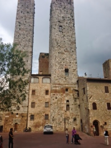
The middle third leads through a dirt track up and down hills and amongst fields filled with wild flowers and the pungent smells of animals in adjoining farms. This section also provided wonderful distant views of the hilltop towers of San Gimignano and took me past monestries where I heard nuns chanting and saw them pacing back and forth in ancient buildings. 

The last third involved walking up over a mountainous bush path literally through private country homes and along the roadside into the outskirts of San Gimignano. The last uphill climb to the village walls lead into the stunning medieval town centre which provides a rewarding end to the 3 hour stage. 

San Gimignano is nothing but breathtaking. Positioned on a hilltop with views over sweeping valleys that resemble a Tuscan postcard, the medieval town is largely unchanged from its 11th Century existence. Dramatically effected by the plague in the 1500s, the population was reduced to near non existence. Although many of the original towers (constructed as a show of power by important families of the time) crumbled or were destroyed in earlier years, the remaining buildings and towers as we see them today display the uniform medieval style. Don't miss a visit to Dondoli Gelateria for the world's best gelato and a porchetta panino washed down with a glass of Chianti or Vernaccia wine.


Tappa 10 in Toscana: San Gimignano to Monteriggioni


The next stage of the route connects the two medieval villages of San Gimignano and Monteriggioni. This was my favourite section of the walk as it weaves through such a diversity of landscapes down roads, dirt pathways, through farms, between vineyards and olive groves, along river banks, passed monestries, churches and castles to arrive at the lesser known Monteriggioni, a medieval town resembling a crown upon a hill top. This stage is long, amounting to around 30km and taking close to 7 hours so it's somewhat of a feat. Although there are some opportunities for filling water bottles at towns or Fontana (taps) along the way, these can be easily missed so it's wise to carry a good supply of water and some snacks for energy. 

The path scrapes the edge of Colle Val d'Elsa, a city on 3 levels including an ancient borgo, a castle and the more modern city on the lower plain. You can divert to visit the ancient buildings, churches and castle if time permits. Nevertheless, it is a most picturesque and unique city. 

An important stop only 2km from Montiriggioni is at Abbadia a Isola. Originating from the Lombards in 1001 with a 12th century church. 

The final climb to the hilltop village of Montiriggioni is steep and leads to one of the town's main gates. The tiny village has the feel of a medieval Hollywood movie set. There are lovely cafés and artisan stores lining the streets and within the main piazza. It's also possible to walk the walls of the ancient castle at a small cost. 


Tappa 11 in Toscana: Monteriggioni to Siena


This section of the Via Francigena involves 20km of mildly undulating pathway leading from Monteriggioni to the beautiful city of Siena. The journey takes 4hours with more road walking than the previous two stages. 

The first half of the route is most picturesque with views back over Monteriggioni and passed castles and historical villas. If possible, extra time to explore the castles, villas and monestries should be added to the journey to enrich the pilgrimage experience. 

The last third of the route involves considerable road walking which, to me, is not as enjoyable. There is quite a climb into Siena but the climax of walking through Siena's gates and along the beautiful streets into Piazza del Campo makes the experience totally worthwhile. 


Some very useful resources for information on each of the stages, including places to stay, visit and eat are:

Website:

Book:
D'Atti M; and Cinti F, Guida Alla Via Fancigena, 5th edition, Terre di Mezzo Editore, 2014


Wednesday 6 August 2014

Hiking on Monte Baldo: Lake Garda

One of my favourite hikes in Italy is the hike from the Monte Baldo cable car station to Cima Pozette, 2253m above Lake Garda. The hike is relatively easy with a climb of around 400m and a duration of approximately 2hours and 45 minutes but the terrain is stone and rock, narrow and exposed. What makes this hike unforgettable, is the stunning 360 degree views every step of the way.

To access the hike, you'll need to travel towards the northern end of the lake to the town of Malcesine. From there, you take 2 cable cars, the second of which rotates in a clockwise direction ensuring all passengers benefit from the stunning views over the lake. The cable car journey takes approximately 20 minutes and the first one in the summer season departs soon after 8am. Although there are seasonal variations, the cable cars depart every 30 minutes but by mid to late morning, when the first full ferries and coaches arrive, the queues can snake diown 2-3 levels of wide stairways and out the entrance, creating a 30minute plus wait. So you're best to arrive between 8-9am for a fuss-free start to your day. 

Upon entering the cable car you'll soon be surrounded by predominately the sounds of German tourists who flurry to Lake Garda throughout the year. Standing shoulder to shoulder and clutching at a hanging hand strap for support, you feel a little like a packed sardine but the journey is pleasant enough as you soar at relatively high speed, ears popping regularly, to reach the 1800m altitude.

Upon exiting at Monte Baldo you immediately notice the cooler temperatures and thinner air. It's often 5-10 degrees cooler than the lakeside temperature and the wind chill factor can make it feel colder. It's wise to pack a long sleeve top or light wind jacket even in the Summer. The last time I visited, it was almost 30 degrees lake side and it felt 10-15 degrees in the harsh winds on the summit, especially when cloud covered the sun. Be prepared for changes in weather conditions, as these are renowned for occurring quickly and without too much warning. There are bathrooms and refreshments at the Monte Baldo cable car station that you can make use of to set yourself up for a pleasant and comfortable start to the day. 

Once set, I'd recommend first heading left from the station up hill and through an archway, past the toboggan run, restaurant, donkeys and alpacas along a goat track that takes you to a wonderful look out point over the northern end of Lake Garda. Along the way you may see dare devil para gliders launching themselves off the cliff towards the lake and beige and tan coloured cows with copper bells hanging fom their thick necks. The clanging of the bells and the whistling wind in your ears, along with the spectacular views over the alps and valleys will have you wanting to sing "the hills are alive ....".
The view from the lookout and throughout the walk are stunning. The return detour to the lookout takes around 45minutes to an hour so make sure you still have plenty of time to complete the main walk. The biggest factor most people need to consider is return transport, being the cable cars and the ferries. The last ferry servicing the southern end of the lake including Garda and Sirmione is at around 5:30pm so you'd be looking at a 4pm cable car to ensure your connection can be made. Therefore, you'd be aiming to start the main hike no later than 1pm. 

The hike starts by heading to the right from the cable car station first down a gravelly path past Ristorante Baia towards a CAI red and white signpost indicating path 651 to Cima Pozzette. The pathway is well way marked throughout with red and white markers. The slowly ascending pathway ranges from grass to goat track to gravel and rock. Soon you enter conservation forest and it's important to observe the rules including keeping to the track, not littering and not collecting or removing objects of any kind. This pristine mountain is a very popular tourist attraction and it would be sad to see it damaged or treated without respect. You'll notice sprinklings of wild flowers from May to October and hear to fluttering of small birds as they fossick in the low lying bushes and pines. 

At times the path is very narrow and you need to watch your footing choosing larger rocks as opposed to loose, sliding gravel. Often the path narrows so that hikers need to give way to each other if approaching from different directions. Heading further along the path you'll see the white stones stacked into piles as you enter low lying pine forest where sometimes it's necessary to duck under the low branches covered with pointy pine needles.

As the path clears, beautiful views down to the lake accompany your every step. The path begins to incline and become more and more rocky and narrow. Soon you reach a sign pointing upwards towards Pozette. The last stretch from here looks a bit daunting. The rock covered mountain top ahead has no resemblance to a walking path but the red and white painted markers on the rocks indicate this is the designated route. After an additional 20 minutes of clambering up, over and between rocks you'll  have the first view of the cross positioned on the summit. A further short and easy incline is all that's needed to complete the journey to the summit of Pozette where the breath taking views in all directions reward you for you efforts and re-energise you for the return trek.

Although the return route is all down hill, it's more difficult and requires more concentration due to the slippery (gravelly) and at times unstable surfaces. Fatigue, thirst, or a lack of concentration can result in a fall so stay attentive and choose your footing wisely. Be careful to always follow the 651 route as otherwise you might veer onto older tracks that, although will all eventually arrive back at the cable car station, have much rougher, rockier and steep terrain. These are situated more to the left of the chair lifts running toward the cable car station at the base of the valley.

Upon your return, enjoy a coffee or aperitivo at one of the restaurant bar tables at Ristorante Baia before returning to Malcesine on the cable cars.

Malcesine is a medieval village on the lake front and is one of the most picturesque towns on the lake. There are plentiful shops, cafés, restaurants, Gelaterias, and medieval ruins and castles to explore. A couple of hours of exploration within the village, or a relaxing drink by the water's edge, is the perfect way to finish a wonderful day.